Aerial Imaging Services in Apex, NC
From the Verdia master-planned community and NC-540 toll road extension to the downtown Salem Street revitalization and Beaver Creek commercial expansion, Apex is North Carolina's fastest-growing town where RDU Class C airspace and explosive residential construction define every data collection.
Apex (North Carolina) is part of the Raleigh-Cary MSA and has a population of approximately 73,866. Apex is the fastest-growing municipality in North Carolina by percentage population growth, positioned in the southwest Wake County tech corridor. The NC-540 toll road extension, Verdia master-planned community, and downtown revitalization are the primary construction drivers. The town is within RDU Class C airspace, making LAANC authorization essential for commercial drone operations.
Serving Wake & the Raleigh-Cary MSA area
Request a Free Quote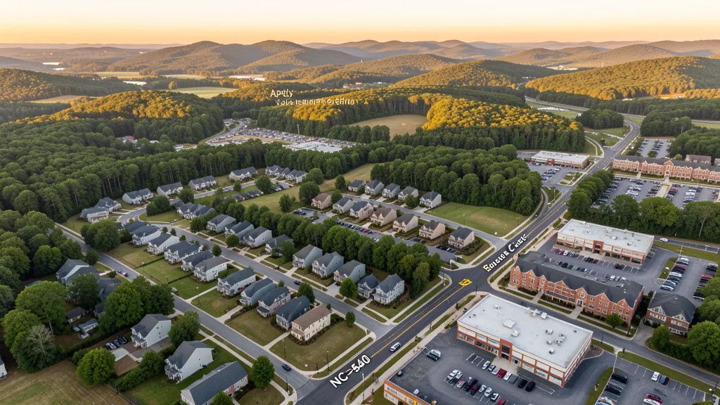
Get a Apex Aerial Quote
Drone Services Serving Apex, NC
Apex is the fastest-growing municipality in North Carolina by percentage population growth, positioned in the southwest Wake County tech corridor. The NC-540 toll road extension, Verdia master-planned community, and downtown revitalization are the primary construction drivers. The town is within RDU Class C airspace, making LAANC authorization essential for commercial drone operations.
How Apex Builders Use Aerial Data
Apex was the fastest-growing municipality in North Carolina by percentage population growth in recent years, driven by its position in the southwest Wake County tech corridor. Major developments include the Verdia master-planned community, the Downtown Apex revitalization along Salem Street, and the expansion of the Beaver Creek commercial district. Infrastructure projects include the NC-540 toll road extension through southwest Apex, the Owen Drive corridor improvements, and the Apex Peakway loop road. Residential construction is concentrated along the Olive Chapel Road and Holly Springs Road corridors.
Active Developers in the Area:
- D.R. Horton (Verdia and southwest Apex master-planned communities)
- Lennar Homes (Olive Chapel Road corridor residential developments)
- Pulte Homes (Haddon Hall and Shepherd's Vineyard area infill)
- Harris Teeter-anchored commercial developments (Beaver Creek district expansion)
- East West Partners (downtown Apex mixed-use and revitalization projects)

Aerial Imaging Pricing Across North Carolina
Cost ranges are based on market data for Raleigh-Cary MSA. Actual pricing depends on site size, complexity, and deliverables.
| Service Type | Low End | High End |
|---|---|---|
| Topographic Data Collection | $1,350 | $5,000 |
| Drone Inspection | $425 | $2,750 |
| LiDAR Scanning | $2,600 | $9,350 |
| Environmental Monitoring | $675 | $3,800 |
| Aerial Imagery | $300 | $1,450 |
| Construction Monitoring | $425 | $2,200 |
| Real Estate Photography | $175 | $900 |
| Roof Inspection | $275 | $1,150 |
Free cost calculator, ROI calculator, and 14-page buyer's guide. No signup required.
Are you a drone operator serving Apex? List your business on AeriusView and get pre-qualified leads in your service area.
List Your Business →Drone Regulations & Airspace Rules for Apex
FAA Part 107 Requirements
Flying for hire in Apex? That is commercial operation under FAA Part 107, which requires a Remote Pilot Certificate — a credential we verify for every operator.
State Drone Laws
Commercial drone work in Apex follows North Carolina UAS law (North Carolina HB 128 (2014)), with city-level rules on top: Apex requires commercial drone operators to hold a valid NCDOT Aviation Division permit in addition to FAA Part 107 certification, per NC HB 128. Full North Carolina drone law →
Local Ordinances
Apex requires commercial drone operators to hold a valid NCDOT Aviation Division permit in addition to FAA Part 107 certification, per NC HB 128. The Apex Parks and Recreation Department prohibits drone takeoff and landing in town parks without a special use permit. Downtown Apex historic district events may require coordination with the Apex Police Department for commercial drone operations. The town is within RDU Class C airspace, making LAANC authorization mandatory for most commercial flights.
Restricted Airspace
- Apex falls within the RDU Class C 10 NM outer ring. Most of the town requires LAANC authorization for commercial drone operations, particularly northern Apex near the US-1 and NC-55 corridors.
- Raleigh Executive Jetport (TTA) Class D airspace is approximately 12 NM south of Apex but may affect operations in southern Wake County.
- Salem Street and downtown Apex historic district have no formal drone restrictions but are densely populated during festivals and events.
- Apex Community Park and Kelly Road Park prohibit drone takeoff and landing without a town permit.
- The Shepherds Vineyard and Haddon Hall residential areas have private property HOA restrictions on drone overflight in common areas.
Airports in the area: RDU — Raleigh-Durham International Airport (Class C airspace, 8 NM north), TTA — Raleigh Executive Jetport (Class D airspace, 12 NM south)
Why Hire Through Aerius View in Apex, NC?
FAA-Certified
Every operator holds an active Part 107 Remote Pilot Certificate.
Local to Apex
Based in the Raleigh-Cary MSA and fluent in North Carolina drone law, with 5 nearby Apex service communities in reach.
No Cost to Quote
Submit your project at no charge. Pay the operator directly if you proceed.
Fast Turnaround
Expect the first call within 2 business days from an operator covering Wake.
AeriusView is expanding in Apex, NC
Apex is an expansion market for the network, with demand driven by projects from D.R. Horton and other local builders. Submit here and a verified operator covering Wake is assigned.
Request a QuoteDrone Data Deliverables for Apex Projects
These are the files you receive with an Apex booking — all compatible with standard construction and engineering software. Projects like those delivered for D.R. Horton across Wake need data that drops straight into their workflow.
- Orthomosaic maps (GeoTIFF) for site overview and documentation
- Point clouds (LAS/LAZ) for 3D modeling and volumetric analysis
- DEM/DSM terrain models for cut/fill and grade analysis
- Contour lines (DXF/DWG, CAD-ready) for Civil 3D and Revit
- Progress reports with side-by-side comparisons for construction monitoring
- Coordinate systems matched to your project datum — the North Carolina State Plane zone, UTM, or a local datum your surveyor specifies
Insurance & Liability Protection
Pilot Insurance Required
Every operator matched to an Apex project carries active liability insurance — minimum $1,000,000 general liability, verified from the certificate before the pilot joins the network. Apex requires commercial drone operators to hold a valid NCDOT Aviation Division permit in addition to FAA Part 107 certification, per NC HB 128. The Apex Parks and Recreation Department prohibits drone takeoff and landing in town parks without a special use permit. Downtown Apex historic district events may require coordination with the Apex Police Department for commercial drone operations. The town is within RDU Class C airspace, making LAANC authorization mandatory for most commercial flights.
FAA Part 107 Verified
Each pilot's Remote Pilot Certificate is checked against the FAA Airmen Inquiry before they can serve Wake bookings. Expired certificates are flagged automatically.
Equipment Documentation
Pilots register their airframes and sensors (RGB, LiDAR, thermal, multispectral) so Apex requests route to crews with the right payload for the job.
Site Safety Coordination
Pilots coordinate with your site superintendent for safe operations on active Apex construction sites, including flight plans that avoid worker areas and equipment zones. Apex requires commercial drone operators to hold a valid NCDOT Aviation Division permit in addition to FAA Part 107 certification, per NC HB 128. The Apex Parks and Recreation Department prohibits drone takeoff and landing in town parks without a special use permit. Downtown Apex historic district events may require coordination with the Apex Police Department for commercial drone operations. The town is within RDU Class C airspace, making LAANC authorization mandatory for most commercial flights.
Drone Services FAQ for Apex, NC
Do I need LAANC authorization to fly a drone in Apex?
Yes for most of Apex. The town falls within the RDU Class C 10 NM outer ring, requiring LAANC authorization for commercial drone operations. Northern Apex, near the US-1 and NC-55 corridors, is closer to the 5 NM inner ring with stricter altitude limits. Always check the FAA B4UFLY app for your specific location.
Can I fly a drone in Apex Community Park?
Only with a special use permit from the Apex Parks and Recreation Department. Commercial drone takeoff and landing in town parks is prohibited without this permit. The park is also within RDU Class C airspace, so LAANC authorization is additionally required.
What is driving construction demand for aerial imaging projects in Apex?
Apex was the fastest-growing town in North Carolina, driven by the Verdia master-planned community, the NC-540 toll road extension, the Beaver Creek commercial district expansion, and downtown Apex revitalization. Residential construction along Olive Chapel Road and Holly Springs Road generates steady demand for topographic and construction monitoring data collection projects.
How much does a drone construction monitoring visit cost in Apex?
Construction monitoring visits in Apex typically range from $400 to $2,100 per session depending on site size and deliverable requirements. Topographic data collection projects run $1,300 to $4,800, and aerial imagery services cost $300 to $1,400.
Are there drone restrictions during Apex Peak City events?
Downtown Apex events along Salem Street, including the Peak City Pig Fest and other festivals, can create crowded conditions where FAA Part 107 rules against flying over people apply. While there may not be formal TFRs, commercial operators should coordinate with Apex Police for event-related drone operations.
Does the NC-540 toll road extension affect drone operations in Apex?
The NC-540 extension through southwest Apex is an active construction zone. Commercial drone operators working on the project should coordinate with NCDOT and the construction contractor. The toll road corridor is within RDU Class C airspace, requiring LAANC authorization. Construction monitoring flights should avoid flying over active traffic lanes per FAA Part 107 rules.
Aerial Imaging Terms for Apex Projects
First aerial project in Apex? These terms cover the deliverables local pilots will quote you. Most Apex projects in our cost table start around $175.
Orthomosaic
A geometrically corrected aerial photo map stitched from many images.
Point Cloud
A 3D dataset of points representing the captured surface.
Real-Time Kinematic
RTK GPS correction for centimeter-level positional accuracy.
LiDAR
Laser scanning that captures terrain through vegetation.
Digital Elevation Model
A 3D representation of terrain elevation across the site.
Ground Control Point
Known reference markers used to anchor and validate mapping accuracy.
Aerial Mapping
Data collection from above to map and measure a site.
Volumetrics
Cut/fill and stockpile volume calculations derived from terrain models.
Are You a Drone Operator in Apex?
Wake buyers search here — 5 active developers tracked in Apex alone. Join the network and get matched leads. First lead free.
Ready to Start Your Project in Apex, NC?
Tell us about your Apex project and we route it to a vetted local pilot — free, no obligation. Projects in Wake start around $175.
Request a Free QuoteAeriusView connects clients with FAA-certified drone operators. Services are not licensed land surveying. Deliverables are not authoritative for boundary determination, design, or legal purposes.