Aerial Imaging Services in Frederick, MD
Frederick golden-hour aerial showing the historic downtown district and Carroll Creek Linear Park nestled against the Catoctin Mountain ridge, with construction cranes visible along the I-270 growth corridor and the Monocacy River winding through the valley.
The Washington-Baltimore-Arlington, DC-MD-VA-WV-PA CSA (Frederick-Gaithersburg-Rockville, MD Metropolitan Division) includes Frederick, where roughly 82,000 residents live in Frederick County. Frederick is one of the fastest-growing cities in Maryland and the anchor of the Frederick-Gaithersburg-Rockville Metropolitan Division, the fastest-growing metro division in the DC-Baltimore CSA. The city's population has grown over 20% since 2010, driven by DC workers seeking more affordable housing and a small-town lifestyle within commuting distance of the capital. The I-270 technology corridor connects Frederick to Montgomery County and DC, making it a prime target for residential and commercial expansion. Major master-planned communities including Urbana, Clover Hill, Spring Ridge, and Wormans Mill have added thousands of residential units with mixed-use retail and office space. The Downtown Frederick expansion along Carroll Creek Park has catalyzed urban revitalization with luxury condominiums, boutique hotels, and office buildings. Frederick Health Village, a 150-acre medical campus expansion, represents one of the largest healthcare construction projects in Maryland. Fort Detrick's expansion and the National Cancer Institute's campus at Riverside Research Park have driven bioscience and federal research construction. The Frederick County Economic Development Office reports over $400 million in annual construction permits, with residential construction accounting for the majority. Commercial development along Route 85 (Buckeystown Pike), the Golden Mile retail corridor, and the Eastalco Industrial Park in Adamstown has driven industrial and logistics construction. Amazon operates a fulfillment center in nearby Urbana. The expansion of MD Route 355 (Urbana Pike) and the new Monocacy Boulevard connector have catalyzed additional commercial development. Construction drone aerial imaging demand is strong for hillside residential grading in the Catoctin foothills, commercial site planning along the I-270 corridor, and infrastructure documentation for road and utility expansion projects.
Serving Frederick County & the Washington-Baltimore-Arlington, DC-MD-VA-WV-PA CSA (Frederick-Gaithersburg-Rockville, MD Metropolitan Division) area
Request a Free Quote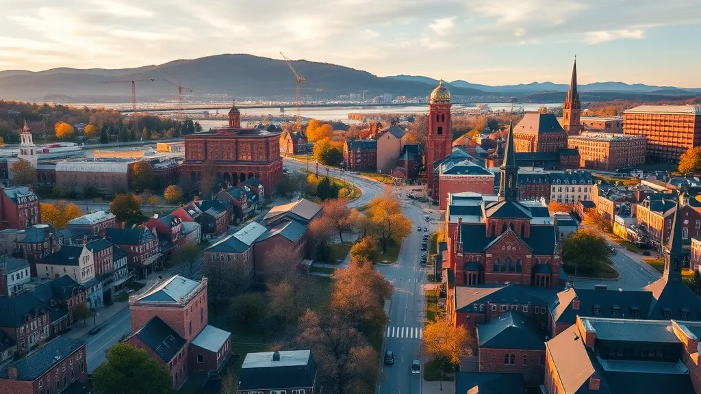
Request a Frederick Drone Operator
Frederick Aerial Imaging Options
Frederick blends historic downtown charm with explosive residential and bioscience construction along the I-270 technology corridor, serving as the primary growth engine for Maryland's Washington-Baltimore CSA. The Catoctin Mountain backdrop and Camp David proximity create unique airspace constraints that make local expertise essential for compliant drone aerial imaging across the region's hillside subdivisions and commercial expansion projects.
Frederick Construction & Development: An Aerial Perspective
Frederick is one of the fastest-growing cities in Maryland and the anchor of the Frederick-Gaithersburg-Rockville Metropolitan Division, the fastest-growing metro division in the DC-Baltimore CSA. The city's population has grown over 20% since 2010, driven by DC workers seeking more affordable housing and a small-town lifestyle within commuting distance of the capital. The I-270 technology corridor connects Frederick to Montgomery County and DC, making it a prime target for residential and commercial expansion. Major master-planned communities including Urbana, Clover Hill, Spring Ridge, and Wormans Mill have added thousands of residential units with mixed-use retail and office space. The Downtown Frederick expansion along Carroll Creek Park has catalyzed urban revitalization with luxury condominiums, boutique hotels, and office buildings. Frederick Health Village, a 150-acre medical campus expansion, represents one of the largest healthcare construction projects in Maryland. Fort Detrick's expansion and the National Cancer Institute's campus at Riverside Research Park have driven bioscience and federal research construction. The Frederick County Economic Development Office reports over $400 million in annual construction permits, with residential construction accounting for the majority. Commercial development along Route 85 (Buckeystown Pike), the Golden Mile retail corridor, and the Eastalco Industrial Park in Adamstown has driven industrial and logistics construction. Amazon operates a fulfillment center in nearby Urbana. The expansion of MD Route 355 (Urbana Pike) and the new Monocacy Boulevard connector have catalyzed additional commercial development. Construction drone aerial imaging demand is strong for hillside residential grading in the Catoctin foothills, commercial site planning along the I-270 corridor, and infrastructure documentation for road and utility expansion projects.
Active Developers in the Area:
- Urbana Communities LLC (NVR/Ryan Homes) — Urbana master-planned community — 3,000+ residential units, Village Center retail, and mixed-use development along I-270 in southern Frederick
- Frederick Health System — Frederick Health Village — 150-acre medical campus expansion including hospital tower, cancer center, and medical office buildings
- The Nally Companies — Luxury townhome and single-family communities in Frederick including Wormans Mill, Whittier, and Hatcher's Run
- Peterson Companies — Mixed-use commercial and retail development along the Golden Mile corridor and Eastalco Industrial Park
- Amazon (AMZN) — 850,000-square-foot fulfillment center in the Urbana area, part of the company's Maryland logistics network expansion
- National Cancer Institute / Fort Detrick — Riverside Research Park bioscience campus expansion and Fort Detrick laboratory modernization programs
What Drone Services Cost in Maryland
These are typical Frederick-area project ranges, drawn from market data across Washington-Baltimore-Arlington, DC-MD-VA-WV-PA CSA (Frederick-Gaithersburg-Rockville, MD Metropolitan Division). Your final price depends on site size, complexity, and deliverables.
| Service Type | Low End | High End |
|---|---|---|
| Topographic Data Collection | $1,250 | $4,700 |
| Drone Inspection | $425 | $2,050 |
| LiDAR Scanning | $2,275 | $8,800 |
| Environmental Monitoring | $525 | $2,700 |
| Aerial Imagery | $275 | $1,350 |
| Construction Monitoring | $400 | $1,850 |
| Real Estate Photography | $225 | $700 |
| Roof Inspection | $275 | $900 |
Free cost calculator, ROI calculator, and 14-page buyer's guide. No signup required.
Are you a drone operator serving Frederick? List your business on AeriusView and get pre-qualified leads in your service area.
List Your Business →Frederick Airspace, FAA Rules & Local Drone Laws
FAA Part 107 Requirements
All commercial drone operations in Maryland require an active FAA Part 107 Remote Pilot Certificate — every operator matched to Frederick projects is verified.
State Drone Laws
Frederick is governed by Maryland state drone law (MD Code § 3-703 voyeurism prohibition and § 4-1201 UAS Task Force framework) and FAA Part 107 regulations. Statewide, Maryland drone law (MD Code § 3-703 (drone voyeurism prohibition); MD Code § 4-1201 et seq (UAS Task Force); HB 128 (2015); HB 693 (2021); FAA Part 107; FAA LAANC; 49 USC § 40103) sets the baseline for commercial operations — Part 107 rules apply on every Frederick job. Full Maryland drone law →
Local Ordinances
Frederick is governed by Maryland state drone law (MD Code § 3-703 voyeurism prohibition and § 4-1201 UAS Task Force framework) and FAA Part 107 regulations. The City of Frederick does not have a specific municipal drone ordinance, meaning commercial drone operations on private property are governed by state law and FAA regulations. Frederick County Parks and Recreation requires a special use permit for commercial drone takeoff and landing in county parks including Ballenger Creek Park, Baker Park, and Catoctin Creek Park. Cunningham Falls State Park and Gambrill State Park require Maryland Park Service special use permits. Catoctin Mountain Park (National Park Service) prohibits all drone operations without a federal special use permit. Fort Detrick, located within city limits, requires coordination with Army base security for any drone operations near its perimeter — unauthorized overflight of the installation is prohibited. Camp David (Naval Support Facility Thurmont), approximately 10 NM northwest, has Prohibited Area P-40 that is activated by NOTAM during presidential visits, creating a 5-NM no-drone zone. Commercial drone operators should check NOTAMs before every flight in western Frederick County. The DC SFRA extends over all of Frederick County, requiring awareness of position relative to the FRZ boundary for operations in southern Frederick County near the Montgomery County line. FAA Part 107 Remote Pilot Certification is required for all commercial operations. LAANC authorization is available at FDK (Class E), IAD (Class B), and BWI (Class C). The Maryland Department of Transportation Aviation Administration encourages all UAS operators to register their operations and coordinate with airport managers.
Restricted Airspace
- Camp David (Naval Support Facility Thurmont), located approximately 10 NM northwest of downtown Frederick in the Catoctin Mountains, is protected by Prohibited Area P-40 — a permanent restricted airspace activated by NOTAM during presidential visits. P-40 creates a no-drone zone with a 5-nautical-mile radius extending from the surface up to 18,000 feet MSL when active. Commercial drone operators in western Frederick County and the Thurmont area must check NOTAMs before every flight, as P-40 can be activated with little notice. LAANC is not available within P-40 when active. This is one of the most sensitive restricted airspaces in the United States and violations are treated as national security incidents with potential federal prosecution and military interception.
- The Washington, DC Flight Restricted Zone (FRZ) is a 15-nautical-mile radius around Ronald Reagan Washington National Airport (DCA) where all drone flights are prohibited without specific FAA authorization through a separate waiver process. The FRZ boundary extends to approximately the Montgomery County line, roughly 20 NM south of Frederick. While downtown Frederick is outside the FRZ, the southern portions of Frederick County near Urbana and Clarksburg approach the FRZ boundary. Operators working in southern Frederick County should verify their position relative to the FRZ using the FAA B4UFLY app. The SFRA (Special Flight Rules Area) extends 30 NM from DCA and includes all of Frederick — drone operators within the SFRA must file a flight plan and operate below 18,000 feet, though commercial Part 107 operations are generally permitted within the SFRA outside the FRZ with LAANC authorization where applicable.
- Fort Detrick, located within the city of Frederick, is a U.S. Army medical research installation with restricted airspace and security zones. While Fort Detrick does not have a formal Class B/C/D airspace designation, the installation maintains a security buffer and requires coordination with base operations for any drone operations near its perimeter. The Army Garrison Fort Detrick prohibits unauthorized drone overflight of the installation and conducts research involving biological agents, making aerial surveillance particularly sensitive. Commercial operators working near the Fort Detrick campus on residential or commercial projects should maintain a safe standoff distance and coordinate with installation security if flight paths approach the base boundary.
- Washington Dulles International Airport (IAD) Class B airspace extends from the surface up to 10,000 feet MSL with multiple layered shelves. The northern Class B shelves reach into southern Frederick County, particularly affecting areas near Urbana, Clarksburg, and the I-270 corridor. LAANC authorization is required and available for commercial drone operations within the IAD Class B lateral boundaries. Operators should check the specific shelf altitude at their flight location — lower shelves may not affect typical Part 107 operations (which are limited to 400 feet AGL), but the surface-area portions around IAD require LAANC clearance.
- The Catoctin Mountain Park and Cunningham Falls State Park, located approximately 12 NM northwest of Frederick near Camp David, are federal and state parklands where commercial drone operations require permits. Catoctin Mountain Park is managed by the National Park Service, which prohibits all drone operations in NPS units without a special use permit issued by the park superintendent. Cunningham Falls State Park requires a Maryland Park Service special use permit for commercial drone takeoff and landing. The adjacent Catoctin Wildlife Preserve and Zoo also restricts drone overflight. These parks are in proximity to P-40 (Camp David), creating overlapping airspace restrictions that require careful NOTAM and permit verification before any commercial flights in the Catoctin Mountain area.
Airports in the area: FDK — Frederick Municipal Airport (Class E airspace, located within Frederick city limits — primary GA airport for Frederick County; LAANC available for Class E surface area), IAD — Washington Dulles International Airport (Class B airspace, approximately 35 NM south of Frederick — major international airport; LAANC required and available within Class B shelves), BWI — Baltimore/Washington International Thurgood Marshall Airport (Class C airspace, approximately 45 NM east-northeast — primary commercial airport for the Baltimore region; LAANC required and available), MTN — Martin State Airport (Class D airspace, approximately 45 NM east — military and general aviation airport supporting Lockheed Martin and Maryland Air National Guard; LAANC required within Class D), GAI — Montgomery County Airpark (Class E airspace, approximately 25 NM south in Gaithersburg — busy GA airport; LAANC available)
Why Frederick Contractors Trust Aerius View
FAA-Certified
Every operator holds an active Part 107 Remote Pilot Certificate.
Local to Frederick
Pilots who fly Frederick regularly — they know the Frederick County staging spots, permit offices, and airspace quirks.
No Cost to Quote
Submit your project at no charge. Pay the operator directly if you proceed.
Fast Turnaround
Expect the first call within 2 business days from an operator covering Frederick County.
AeriusView is expanding in Frederick, MD
Pilot coverage for Frederick is filling in — surrounding Washington-Baltimore-Arlington, DC-MD-VA-WV-PA CSA (Frederick-Gaithersburg-Rockville, MD Metropolitan Division) cities are already served. Requests from Frederick are routed to the nearest verified operator.
Request a QuoteWhat Aerial Data Products Do You Receive in Frederick?
a Frederick project wraps with professional-grade deliverables built for the software stacks Frederick County crews already run. Projects like those delivered for Urbana Communities LLC across Frederick County need data that drops straight into their workflow.
- DEM/DSM terrain models for cut/fill and grade analysis
- Contour lines (DXF/DWG, CAD-ready) for Civil 3D and Revit
- Progress reports with side-by-side comparisons for construction monitoring
- Orthomosaic maps (GeoTIFF) for site overview and documentation
- Point clouds (LAS/LAZ) for 3D modeling and volumetric analysis
- Coordinate systems matched to your project datum — the Maryland State Plane zone, UTM, or a local datum your surveyor specifies
Insurance & Liability Protection
Pilot Insurance Required
Every operator matched to a Frederick project carries active liability insurance — minimum $1,000,000 general liability, verified from the certificate before the pilot joins the network. Frederick is governed by Maryland state drone law (MD Code § 3-703 voyeurism prohibition and § 4-1201 UAS Task Force framework) and FAA Part 107 regulations. The City of Frederick does not have a specific municipal drone ordinance, meaning commercial drone operations on private property are governed by state law and FAA regulations. Frederick County Parks and Recreation requires a special use permit for commercial drone takeoff and landing in county parks including Ballenger Creek Park, Baker Park, and Catoctin Creek Park. Cunningham Falls State Park and Gambrill State Park require Maryland Park Service special use permits. Catoctin Mountain Park (National Park Service) prohibits all drone operations without a federal special use permit. Fort Detrick, located within city limits, requires coordination with Army base security for any drone operations near its perimeter — unauthorized overflight of the installation is prohibited. Camp David (Naval Support Facility Thurmont), approximately 10 NM northwest, has Prohibited Area P-40 that is activated by NOTAM during presidential visits, creating a 5-NM no-drone zone. Commercial drone operators should check NOTAMs before every flight in western Frederick County. The DC SFRA extends over all of Frederick County, requiring awareness of position relative to the FRZ boundary for operations in southern Frederick County near the Montgomery County line. FAA Part 107 Remote Pilot Certification is required for all commercial operations. LAANC authorization is available at FDK (Class E), IAD (Class B), and BWI (Class C). The Maryland Department of Transportation Aviation Administration encourages all UAS operators to register their operations and coordinate with airport managers.
FAA Part 107 Verified
Each pilot's Remote Pilot Certificate is checked against the FAA Airmen Inquiry before they can serve Frederick County bookings. Expired certificates are flagged automatically.
Equipment Documentation
Pilots register their airframes and sensors (RGB, LiDAR, thermal, multispectral) so Frederick requests route to crews with the right payload for the job.
Site Safety Coordination
Pilots coordinate with your site superintendent for safe operations on active Frederick construction sites, including flight plans that avoid worker areas and equipment zones. Frederick is governed by Maryland state drone law (MD Code § 3-703 voyeurism prohibition and § 4-1201 UAS Task Force framework) and FAA Part 107 regulations. The City of Frederick does not have a specific municipal drone ordinance, meaning commercial drone operations on private property are governed by state law and FAA regulations. Frederick County Parks and Recreation requires a special use permit for commercial drone takeoff and landing in county parks including Ballenger Creek Park, Baker Park, and Catoctin Creek Park. Cunningham Falls State Park and Gambrill State Park require Maryland Park Service special use permits. Catoctin Mountain Park (National Park Service) prohibits all drone operations without a federal special use permit. Fort Detrick, located within city limits, requires coordination with Army base security for any drone operations near its perimeter — unauthorized overflight of the installation is prohibited. Camp David (Naval Support Facility Thurmont), approximately 10 NM northwest, has Prohibited Area P-40 that is activated by NOTAM during presidential visits, creating a 5-NM no-drone zone. Commercial drone operators should check NOTAMs before every flight in western Frederick County. The DC SFRA extends over all of Frederick County, requiring awareness of position relative to the FRZ boundary for operations in southern Frederick County near the Montgomery County line. FAA Part 107 Remote Pilot Certification is required for all commercial operations. LAANC authorization is available at FDK (Class E), IAD (Class B), and BWI (Class C). The Maryland Department of Transportation Aviation Administration encourages all UAS operators to register their operations and coordinate with airport managers.
Frederick, MD Drone & Aerial Imaging Questions
Can I fly a drone near Camp David in Frederick County?
Camp David (Naval Support Facility Thurmont), approximately 10 NM northwest of downtown Frederick, is protected by Prohibited Area P-40 — one of the most restrictive airspaces in the United States. P-40 creates a 5-nautical-mile no-drone zone from the surface up to 18,000 feet when activated by NOTAM during presidential visits. LAANC is not available within P-40. Violations are treated as national security incidents with potential military interception and federal prosecution. Commercial drone operators in the Thurmont and Catoctin Mountain area must check NOTAMs before every flight, as P-40 can be activated with little notice. Always verify P-40 status using the FAA B4UFLY app or the FAA NOTAM system.
Is Frederick within the Washington DC Flight Restricted Zone?
Downtown Frederick is outside the 15-nautical-mile DC Flight Restricted Zone (FRZ) centered on Reagan National Airport (DCA). However, southern Frederick County near Urbana and Clarksburg approaches the FRZ boundary. All of Frederick County is within the 30-NM DC Special Flight Rules Area (SFRA), which requires awareness of your position relative to the FRZ. Commercial Part 107 operations are generally permitted within the SFRA outside the FRZ, but operators in southern Frederick County should verify their position using the FAA B4UFLY app. The FRZ itself prohibits all drone flights without specific FAA authorization through a separate waiver process.
Do I need LAANC authorization to fly a drone in Frederick?
It depends on your location. Frederick Municipal Airport (FDK) operates in Class E airspace where LAANC is available but not always mandatory for surface-level Part 107 operations. The northern shelves of Washington Dulles International Airport (IAD) Class B airspace extend into southern Frederick County near Urbana — LAANC authorization is required and available for flights within the Class B lateral boundaries. Baltimore/Washington International (BWI) Class C airspace is approximately 45 NM east and generally does not affect Frederick operations. Always check the FAA B4UFLY app for your specific flight location to determine airspace class and LAANC requirements.
Can I fly a drone over Fort Detrick in Frederick?
No. Fort Detrick, located within the city of Frederick, is a U.S. Army medical research installation that prohibits unauthorized drone overflight. While Fort Detrick does not have a formal Class B/C/D airspace designation, the installation maintains a security buffer and coordinates with federal authorities on aerial surveillance concerns. The base conducts biological research, making unauthorized drone overflight particularly sensitive. Commercial operators working on nearby residential or commercial projects should maintain a safe standoff distance from the base perimeter and coordinate with installation security if flight paths approach the Fort Detrick boundary.
How much does an aerial imaging cost for a residential subdivision in Frederick?
Topographic drone data collection for residential subdivisions in Frederick typically range from $1,200 to $4,500 depending on acreage, terrain complexity (hillside sites in the Catoctin foothills cost more), and proximity to IAD Class B or Camp David P-40 airspace. Construction monitoring visits cost $400 to $1,800 per session. LiDAR scanning for precise grading verification on hillside lots runs $2,200 to $8,500. The mix of flat farmland and hillside terrain in Frederick County creates variable data collection complexity that drone-based methods handle efficiently compared to traditional ground data collection projects.
Can I fly a drone in Frederick County parks for commercial purposes?
Commercial drone takeoff and landing in Frederick County parks including Ballenger Creek Park, Baker Park, and Catoctin Creek Park require a special use permit from Frederick County Parks and Recreation. Cunningham Falls State Park and Gambrill State Park require Maryland Park Service special use permits. Catoctin Mountain Park, managed by the National Park Service, prohibits all drone operations without a federal special use permit from the park superintendent. FAA Part 107 prohibits flying directly over non-participants. Always verify airspace class and NOTAMs (especially P-40 for Camp David) using the FAA B4UFLY app before any commercial flight in the Frederick area.
Aerial Imaging Terms for Frederick Projects
The vocabulary behind Frederick aerial data — useful before you request quotes. Most Frederick projects in our cost table start around $225.
Point Cloud
A 3D dataset of points representing the captured surface.
Real-Time Kinematic
RTK GPS correction for centimeter-level positional accuracy.
LiDAR
Laser scanning that captures terrain through vegetation.
Digital Elevation Model
A 3D representation of terrain elevation across the site.
Ground Control Point
Known reference markers used to anchor and validate mapping accuracy.
Aerial Mapping
Data collection from above to map and measure a site.
Volumetrics
Cut/fill and stockpile volume calculations derived from terrain models.
Thermal Imaging
Infrared capture that reveals heat signatures for inspections.
Nearby Cities
Are You a Drone Operator in Frederick?
Serve Frederick and the wider Washington-Baltimore-Arlington, DC-MD-VA-WV-PA CSA (Frederick-Gaithersburg-Rockville, MD Metropolitan Division) : leads routed by service area, no fees to join, first lead free.
Ready to Start Your Project in Frederick, MD?
One form, then a Washington-Baltimore-Arlington, DC-MD-VA-WV-PA CSA (Frederick-Gaithersburg-Rockville, MD Metropolitan Division)-based operator follows up with a quote. No cost, no commitment. Projects in Frederick County start around $225.
Request a Free QuoteAeriusView connects clients with FAA-certified drone operators. Services are not licensed land surveying. Deliverables are not authoritative for boundary determination, design, or legal purposes.