Aerial Imaging Services in Wesley Chapel, NC
From the Weddington Chase and Bonterra upscale residential corridors to the Sky Brook community and Weddington Road growth area, Wesley Chapel is a fast-growing Union County village where open airspace and premium residential development shape every data collection mission.
The Charlotte-Concord-Gastonia MSA includes Wesley Chapel, where roughly 23,841 residents live in Union. Wesley Chapel is an upscale Union County village adjacent to Weddington and Indian Trail. The village has experienced rapid residential growth with master-planned communities like Weddington Chase, Bonterra, and Sky Brook. The area attracts affluent buyers seeking larger lots and top-rated school districts while maintaining proximity to Charlotte via US-74 and I-485. Commercial development along Weddington Road and Wesley Chapel Road includes neighborhood retail and service businesses. Single-family residential construction dominates, with custom and semi-custom homes driving demand for topographic data collection and aerial imagery.
Serving Union & the Charlotte-Concord-Gastonia MSA area
Request a Free Quote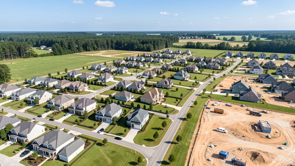
Request a Wesley Chapel Drone Operator
Wesley Chapel Aerial Imaging Options
Wesley Chapel is an upscale Union County village adjacent to Weddington and Indian Trail. Master-planned communities like Weddington Chase, Bonterra, and Sky Brook attract affluent buyers seeking larger lots and top-rated schools. The village benefits from US-74 and I-485 proximity while maintaining a suburban-rural character.
What Drone Services Cost in North Carolina
These are typical Wesley Chapel-area project ranges, drawn from market data across Charlotte-Concord-Gastonia MSA. Your final price depends on site size, complexity, and deliverables.
| Service Type | Low End | High End |
|---|---|---|
| Topographic Data Collection | $1,075 | $3,900 |
| Drone Inspection | $400 | $2,150 |
| LiDAR Scanning | $1,900 | $7,150 |
| Environmental Monitoring | $575 | $2,850 |
| Aerial Imagery | $275 | $1,250 |
| Construction Monitoring | $325 | $1,750 |
| Real Estate Photography | $200 | $750 |
| Roof Inspection | $250 | $950 |
Free cost calculator, ROI calculator, and 14-page buyer's guide. No signup required.
Are you a drone operator serving Wesley Chapel? List your business on AeriusView and get pre-qualified leads in your service area.
List Your Business →Wesley Chapel Airspace, FAA Rules & Local Drone Laws
FAA Part 107 Requirements
All commercial drone operations in North Carolina require an active FAA Part 107 Remote Pilot Certificate — every operator matched to Wesley Chapel projects is verified.
State Drone Laws
Wesley Chapel follows NC state law requiring NCDOT commercial drone operator permits. Statewide, North Carolina drone law (North Carolina HB 128 (2014)) sets the baseline for commercial operations — Part 107 rules apply on every Wesley Chapel job. Full North Carolina drone law →
Local Ordinances
Wesley Chapel follows NC state law requiring NCDOT commercial drone operator permits. Union County parks prohibit drone takeoff and landing without a permit. The village has experienced rapid upscale residential growth, and commercial drone operations near active construction zones should coordinate with site managers.
Restricted Airspace
- Wesley Chapel is generally outside Charlotte Douglas Class B airspace. Commercial operators should verify on the FAA LAANC map.
- Monroe Regional Airport (EQY) Class E airspace is approximately 7 NM southeast with no LAANC requirement but FAA notification procedures apply.
- Union County parks prohibit drone takeoff and landing without a local permit.
- The Weddington Road residential corridor has no specific restrictions but active construction zones require coordination with site managers.
Airports in the area: CLT — Charlotte Douglas International Airport (Class B airspace, approximately 16 NM west), EQY — Monroe Regional Airport (Class E airspace, approximately 7 NM southeast)
Wesley Chapel Construction & Development: An Aerial Perspective
Wesley Chapel is an upscale Union County village adjacent to Weddington and Indian Trail. The village has experienced rapid residential growth with master-planned communities like Weddington Chase, Bonterra, and Sky Brook. The area attracts affluent buyers seeking larger lots and top-rated school districts while maintaining proximity to Charlotte via US-74 and I-485. Commercial development along Weddington Road and Wesley Chapel Road includes neighborhood retail and service businesses. Single-family residential construction dominates, with custom and semi-custom homes driving demand for topographic data collection and aerial imagery.
Active Developers in the Area:
- Saussy Burbank (Weddington Chase and Bonterra communities)
- Lennar Carolinas (Wesley Chapel residential subdivisions)
- Davidson Homes (upscale residential in Wesley Chapel)
- DR Horton (Union County residential development)
- Crescent Communities (mixed-use near Wesley Chapel Road)

Why Wesley Chapel Contractors Trust Aerius View
FAA-Certified
Every operator holds an active Part 107 Remote Pilot Certificate.
Local to Wesley Chapel
Pilots who fly Wesley Chapel regularly — they know the Union staging spots, permit offices, and airspace quirks.
No Cost to Quote
Submit your project at no charge. Pay the operator directly if you proceed.
Fast Turnaround
A local operator contacts you within 2 business days — typical for Charlotte-Concord-Gastonia MSA jobs.
AeriusView is expanding in Wesley Chapel, NC
Pilot coverage for Wesley Chapel is filling in — surrounding Charlotte-Concord-Gastonia MSA cities are already served. Requests from Wesley Chapel are routed to the nearest verified operator.
Request a QuoteWhat Aerial Data Products Do You Receive in Wesley Chapel?
a Wesley Chapel project wraps with professional-grade deliverables built for the software stacks Union crews already run. Projects like those delivered for Saussy Burbank across Union need data that drops straight into their workflow.
- Orthomosaic maps (GeoTIFF) for site overview and documentation
- Point clouds (LAS/LAZ) for 3D modeling and volumetric analysis
- DEM/DSM terrain models for cut/fill and grade analysis
- Contour lines (DXF/DWG, CAD-ready) for Civil 3D and Revit
- Progress reports with side-by-side comparisons for construction monitoring
- Coordinate systems matched to your project datum — the North Carolina State Plane zone, UTM, or a local datum your surveyor specifies
Insurance & Liability Protection
Pilot Insurance Required
Every operator matched to a Wesley Chapel project carries active liability insurance — minimum $1,000,000 general liability, verified from the certificate before the pilot joins the network. Wesley Chapel follows NC state law requiring NCDOT commercial drone operator permits. Union County parks prohibit drone takeoff and landing without a permit. The village has experienced rapid upscale residential growth, and commercial drone operations near active construction zones should coordinate with site managers.
FAA Part 107 Verified
Each pilot's Remote Pilot Certificate is checked against the FAA Airmen Inquiry before they can serve Union bookings. Expired certificates are flagged automatically.
Equipment Documentation
Pilots register their airframes and sensors (RGB, LiDAR, thermal, multispectral) so Wesley Chapel requests route to crews with the right payload for the job.
Site Safety Coordination
Pilots coordinate with your site superintendent for safe operations on active Wesley Chapel construction sites, including flight plans that avoid worker areas and equipment zones. Wesley Chapel follows NC state law requiring NCDOT commercial drone operator permits. Union County parks prohibit drone takeoff and landing without a permit. The village has experienced rapid upscale residential growth, and commercial drone operations near active construction zones should coordinate with site managers.
Wesley Chapel, NC Drone & Aerial Imaging Questions
Do I need LAANC authorization to fly a drone in Wesley Chapel?
Wesley Chapel is generally outside Charlotte Douglas Class B controlled airspace. Monroe Regional Airport (EQY) has uncontrolled Class E airspace approximately 7 NM southeast with no LAANC requirement, but commercial operators should follow FAA notification procedures.
What is driving construction demand in Wesley Chapel?
Upscale residential development including Weddington Chase, Bonterra, and Sky Brook master-planned communities is the primary driver. The village attracts affluent buyers seeking larger lots and top-rated schools while maintaining proximity to Charlotte.
What is the cost of an aerial imaging in Wesley Chapel?
Topographic drone data collection range from $1,100 to $4,000 depending on acreage. Construction monitoring visits cost $350 to $1,800 per session. LiDAR scanning runs $2,000 to $7,500. Real estate photography commands premium rates for upscale properties.
Does Wesley Chapel have a local drone ordinance?
Wesley Chapel follows NC state law requiring NCDOT commercial drone operator permits. Union County parks prohibit drone takeoff and landing without a permit. The village does not have a separate drone-specific ordinance beyond state requirements.
Are there restrictions near the Weddington Chase community?
There are no specific airspace restrictions over residential communities. However, commercial drone flights over private residential property require homeowner awareness per FAA Part 107 privacy guidelines. Coordinate with community management for construction monitoring flights.
How does Wesley Chapel differ from other Union County towns for drone operations?
Wesley Chapel has larger lot sizes and more upscale residential development than Indian Trail or Stallings. This means lower housing density but larger per-property data collection areas. The village is incorporated and has its own planning jurisdiction, so coordinate with village planning for commercial operations.
Aerial Imaging Terms for Wesley Chapel Projects
The vocabulary behind Wesley Chapel aerial data — useful before you request quotes. Most Wesley Chapel projects in our cost table start around $200.
Point Cloud
A 3D dataset of points representing the captured surface.
Real-Time Kinematic
RTK GPS correction for centimeter-level positional accuracy.
LiDAR
Laser scanning that captures terrain through vegetation.
Digital Elevation Model
A 3D representation of terrain elevation across the site.
Ground Control Point
Known reference markers used to anchor and validate mapping accuracy.
Aerial Mapping
Data collection from above to map and measure a site.
Volumetrics
Cut/fill and stockpile volume calculations derived from terrain models.
Thermal Imaging
Infrared capture that reveals heat signatures for inspections.
Are You a Drone Operator in Wesley Chapel?
Serve Wesley Chapel and the wider Charlotte-Concord-Gastonia MSA : leads routed by service area, no fees to join, first lead free.
Ready to Start Your Project in Wesley Chapel, NC?
One form, then a Charlotte-Concord-Gastonia MSA-based operator follows up with a quote. No cost, no commitment. Projects in Union start around $200.
Request a Free QuoteAeriusView connects clients with FAA-certified drone operators. Services are not licensed land surveying. Deliverables are not authoritative for boundary determination, design, or legal purposes.