Aerial Imaging Services in Kalispell, MT
Kalispell golden-hour aerial showing the Flathead Valley with the Swan Mountain Range to the east, Glacier National Park peaks on the northern horizon, and the fast-growing residential subdivisions spreading across the valley floor.
Located in Flathead with a population of 25,000, Kalispell sits within the Kalispell, MT Micropolitan Statistical Area (Flathead Valley, northwest Montana). Kalispell and the broader Flathead Valley comprise the fastest-growing micropolitan area in Montana and one of the fastest in the United States, with Flathead County population growth exceeding 2.5% annually. The Kalispell micropolitan area has grown from approximately 95,000 in 2018 to over 110,000 in 2024, driven by an influx of remote workers, retirees, and outdoor recreation enthusiasts. Construction activity in 2024-2025 is exceptionally strong across all sectors. Residential development dominates the market, with major subdivisions including the Farm District north of Kalispell, the Glacier Hill subdivision off Rose Crossing, the Aspen Creek development in west Kalispell, and the Eagle Creek Ranch subdivision south of town. The city issued over 500 residential building permits in 2024, with average new home prices exceeding $500,000 in the Flathead Valley. Commercial construction includes the massive Logan Health Medical Center campus expansion (new pediatric tower and cancer treatment center), the Glacier Park International Airport terminal expansion and parking garage, the downtown Main Street mixed-use redevelopment, and the north reserve commercial corridor buildout along US-93. The Montana Department of Transportation US-93 Kalispell bypass project, the Reserve Drive widening, and the Whitefish Stage Road improvements represent major infrastructure spending. Industrial construction includes the Weyerhaeuser facility upgrades, the Flathead Electric Cooperative headquarters expansion, and warehouse development along the railway spur corridor.
Serving Flathead & the Kalispell, MT Micropolitan Statistical Area (Flathead Valley, northwest Montana) area
Request a Free Quote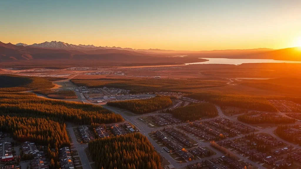
Get Matched With a Local Drone Operator
Aerial Data Services for Kalispell Projects
As the commercial hub of the Flathead Valley and primary gateway to Glacier National Park, Kalispell has become Montana's most rapidly expanding micropolitan area. With over 500 residential permits issued in 2024, a major medical center tower expansion, the FCA terminal rebuild, and the US-93 bypass project, construction activity spans from the Farm District to Glacier Hill. The mountain valley terrain, Class D airspace around the airport, and proximity to a no-drone national park create distinct operational considerations for aerial mappingors.
Local Airspace & Regulations in Kalispell, MT
FAA Part 107 Requirements
Part 107 is the federal baseline for paid drone work in Kalispell. Each operator in the network holds an active Remote Pilot Certificate, verified at onboarding.
State Drone Laws
Kalispell sits under Montana's statewide UAS framework (Mont. Code Ann. § 60-1-101 (aircraft definition includes UAS); Mont. Code Ann. § 2-15-3106 (DOT aviation authority)); local permitting in Flathead is what varies site to site. Kalispell does not have a comprehensive city-specific drone ordinance, relying on FAA Part 107 regulations and Montana state law. Full Montana drone law →
Local Ordinances
Kalispell does not have a comprehensive city-specific drone ordinance, relying on FAA Part 107 regulations and Montana state law. Commercial drone operators must hold a valid FAA Part 107 Remote Pilot Certificate. The Kalispell Parks and Recreation Department requires authorization for commercial drone takeoff and landing on city-owned park property, including Depot Park, Lawrence Park, and Bissett Park. Operations near Glacier Park International Airport (FCA) require LAANC authorization for the Class D surface area within 4 NM of the airport. Montana Fish, Wildlife & Parks requires permits for drone operations in state parks, including Wildhorse Island State Park in Flathead Lake and Lone Pine State Park overlooking the valley. Flathead County has no separate drone ordinance but defers to FAA Part 107 for commercial operations. The Flathead National Forest ranger district may require special use permits for commercial drone operations on Forest Service lands surrounding the Flathead Valley. Montana Code Annotated § 60-1-101 includes drones in the definition of aircraft, but the state defers to FAA authority for Part 107 commercial operations.
Restricted Airspace
- Glacier Park International Airport (FCA) has Class D airspace extending from the surface to 6,800 feet MSL within 4 nautical miles of the airport. LAANC authorization is required for commercial drone operations within this controlled airspace. FCA serves as the primary commercial airport for the Flathead Valley and Glacier National Park gateway, handling over 400,000 passengers annually with service from United, Delta, Alaska, and Allegiant. The airport is located 8 miles northeast of downtown Kalispell near Columbia Heights. Drone operators must use the FAA B4UFLY app or approved LAANC providers (Aloft, AirMap) for authorization before flying within the Class D surface area. FCA air traffic control tower frequency is 118.3 MHz.
- Glacier National Park, located approximately 30 miles northeast of Kalispell, is a no-drone zone in its entirety. The National Park Service prohibits the operation of unmanned aircraft within all national park units under Policy Memorandum 14-05. Commercial drone operators may not fly over, launch from, or land within Glacier National Park boundaries. The west entrance at West Glacier is 33 miles from Kalispell, and the Camas Creek entrance is accessible via the North Fork Road. Operators conducting aerial mapping work near the park boundary must verify their flight area does not cross into NPS jurisdiction. Violations carry federal penalties under 36 CFR 1.5 and NPS policy directives.
- Flathead Lake, the largest natural freshwater lake west of the Mississippi, dominates the valley south of Kalispell. While not a formal no-drone zone, the lake has heavy recreational boat traffic in summer, with marinas at Lakeside, Bigfork, and Somers. FAA Part 107 prohibits flying directly over non-participants, including boaters, swimmers, and paddlers. The Flathead Lake Marine Patrol and Lakeside marina areas have high seasonal density. Drone operators conducting real estate or data collection work along the lake shore should maintain altitude awareness, avoid flying over occupied beaches and docks, and coordinate with waterfront property owners. Wildhorse Island, a state park within the lake, requires Montana Fish, Wildlife & Parks permits for commercial drone operations.
- The Kalispell Regional Medical Center (now Logan Health Medical Center) campus in north Kalispell has helicopter emergency medical services (HEMS) operations. The hospital operates Life Flight Network and ALERT helicopter services with rooftop and ground-level helipads. Drone operators should maintain awareness of HEMS flight corridors, especially during emergency medical calls serving the entire Flathead Valley and Glacier National Park backcountry. The FAA requires drone operators to yield right-of-way to all manned aircraft, including emergency helicopters. Commercial drone aerial imaging work near the Logan Health campus at 310 Sunnyview Lane should coordinate with hospital facilities management and monitor aviation radio frequencies (122.9 MHz) for HEMS activity.
- The Flathead National Forest surrounds Kalispell on multiple sides, encompassing the Swan Range, Whitefish Range, and Flathead Range. Commercial drone operations on Forest Service lands — including mapping, aerial imaging, real estate photography, or any revenue-generating aerial work — may require a special use permit from the Flathead National Forest supervisor office. The Great Bear Wilderness and Mission Mountains Wilderness areas adjacent to the valley have additional restrictions on motorized equipment. Drone operators conducting work near timber sale boundaries, USFS recreation sites, or wilderness area peripheries should contact the Flathead National Forest at (406) 758-5208 to determine permit requirements. Flying over designated wilderness areas is discouraged and may have additional restrictions under Forest Service policy.
Airports in the area: FCA — Glacier Park International Airport (Class D airspace, 8 miles northeast, controlled airspace requiring LAANC for commercial drone ops within 4 NM, busiest airport in northwest Montana serving Glacier National Park gateway), S27 — Kalispell City Airport (Class E airspace, 2 miles south of downtown, general aviation, no control tower, busiest GA airport in Montana by operations), HVR — Havre City-County Airport (Class E airspace, 220 miles east, general aviation reference for northern Montana ops), S49 — Whitefish Airport (Class E airspace, 15 miles north, general aviation, uncontrolled airspace, seasonal recreational traffic)
Typical Project Costs in Montana
What Kalispell projects usually cost, based on current Kalispell, MT Micropolitan Statistical Area (Flathead Valley, northwest Montana) market data. Exact pricing depends on site size, complexity, and deliverables.
| Service Type | Low End | High End |
|---|---|---|
| Topographic Data Collection | $875 | $3,100 |
| Drone Inspection | $300 | $1,450 |
| LiDAR Scanning | $1,750 | $6,200 |
| Environmental Monitoring | $525 | $2,100 |
| Aerial Imagery | $250 | $950 |
| Construction Monitoring | $300 | $1,250 |
| Real Estate Photography | $150 | $500 |
| Roof Inspection | $250 | $700 |
Free cost calculator, ROI calculator, and 14-page buyer's guide. No signup required.
Are you a drone operator serving Kalispell? List your business on AeriusView and get pre-qualified leads in your service area.
List Your Business →Aerial Imaging for Kalispell's Construction Market
Kalispell and the broader Flathead Valley comprise the fastest-growing micropolitan area in Montana and one of the fastest in the United States, with Flathead County population growth exceeding 2.5% annually. The Kalispell micropolitan area has grown from approximately 95,000 in 2018 to over 110,000 in 2024, driven by an influx of remote workers, retirees, and outdoor recreation enthusiasts. Construction activity in 2024-2025 is exceptionally strong across all sectors. Residential development dominates the market, with major subdivisions including the Farm District north of Kalispell, the Glacier Hill subdivision off Rose Crossing, the Aspen Creek development in west Kalispell, and the Eagle Creek Ranch subdivision south of town. The city issued over 500 residential building permits in 2024, with average new home prices exceeding $500,000 in the Flathead Valley. Commercial construction includes the massive Logan Health Medical Center campus expansion (new pediatric tower and cancer treatment center), the Glacier Park International Airport terminal expansion and parking garage, the downtown Main Street mixed-use redevelopment, and the north reserve commercial corridor buildout along US-93. The Montana Department of Transportation US-93 Kalispell bypass project, the Reserve Drive widening, and the Whitefish Stage Road improvements represent major infrastructure spending. Industrial construction includes the Weyerhaeuser facility upgrades, the Flathead Electric Cooperative headquarters expansion, and warehouse development along the railway spur corridor.
Active Developers in the Area:
- Swank Enterprises (Kalispell-based commercial and residential — active on Glacier Hill subdivision and luxury lakefront properties throughout Flathead Valley)
- Dick Anderson Construction (Montana-wide infrastructure and commercial — active on US-93 bypass and Logan Health Medical Center expansion)
- Cowan Construction (Kalispell residential and custom homes — active in the Farm District and Eagle Creek Ranch subdivisions)
- LHC Incorporated (Flathead Valley commercial and retail — active on north reserve commercial corridor and downtown Main Street redevelopment)
- Lange Custom Homes (Whitefish and Kalispell luxury residential — active in lakefront properties and Whitefish range commute corridor developments)
- Cheema Construction (regional infrastructure and highway — US-93 Kalispell bypass and Reserve Drive widening projects in Flathead County)
Why Kalispell Project Managers Choose Aerius View
FAA-Certified
Every operator holds an active Part 107 Remote Pilot Certificate.
Local to Kalispell
Operators working Flathead daily — familiar with Kalispell, MT Micropolitan Statistical Area (Flathead Valley, northwest Montana) airspace including FCA — Glacier Park International Airport (Class D airspace, 8 miles northeast, controlled airspace requiring LAANC for commercial drone ops within 4 NM, busiest airport in northwest Montana serving Glacier National Park gateway) and local permitting.
No Cost to Quote
Submit your project at no charge. Pay the operator directly if you proceed.
Fast Turnaround
Quotes in Kalispell commonly move inside 2 business days once your request is in.
AeriusView is expanding in Kalispell, MT
AeriusView is building its Kalispell network now — active development work by teams like Swank Enterprises keeps demand high. Nearby coverage is live across 4 surrounding cities, so projects in Kalispell are matched on arrival.
Request a QuoteWhat Deliverables Do You Get?
Every Kalispell project includes professional-grade deliverables compatible with the construction and engineering software used across the Kalispell, MT Micropolitan Statistical Area (Flathead Valley, northwest Montana). Projects like those delivered for Swank Enterprises across Flathead need data that drops straight into their workflow.
- Progress reports with side-by-side comparisons for construction monitoring
- Orthomosaic maps (GeoTIFF) for site overview and documentation
- Point clouds (LAS/LAZ) for 3D modeling and volumetric analysis
- DEM/DSM terrain models for cut/fill and grade analysis
- Contour lines (DXF/DWG, CAD-ready) for Civil 3D and Revit
- Coordinate systems matched to your project datum — the Montana State Plane zone, UTM, or a local datum your surveyor specifies
Insurance & Liability Protection
Pilot Insurance Required
Every operator matched to a Kalispell project carries active liability insurance — minimum $1,000,000 general liability, verified from the certificate before the pilot joins the network. Kalispell does not have a comprehensive city-specific drone ordinance, relying on FAA Part 107 regulations and Montana state law. Commercial drone operators must hold a valid FAA Part 107 Remote Pilot Certificate. The Kalispell Parks and Recreation Department requires authorization for commercial drone takeoff and landing on city-owned park property, including Depot Park, Lawrence Park, and Bissett Park. Operations near Glacier Park International Airport (FCA) require LAANC authorization for the Class D surface area within 4 NM of the airport. Montana Fish, Wildlife & Parks requires permits for drone operations in state parks, including Wildhorse Island State Park in Flathead Lake and Lone Pine State Park overlooking the valley. Flathead County has no separate drone ordinance but defers to FAA Part 107 for commercial operations. The Flathead National Forest ranger district may require special use permits for commercial drone operations on Forest Service lands surrounding the Flathead Valley. Montana Code Annotated § 60-1-101 includes drones in the definition of aircraft, but the state defers to FAA authority for Part 107 commercial operations.
FAA Part 107 Verified
Each pilot's Remote Pilot Certificate is checked against the FAA Airmen Inquiry before they can serve Flathead bookings. Expired certificates are flagged automatically.
Equipment Documentation
Pilots register their airframes and sensors (RGB, LiDAR, thermal, multispectral) so Kalispell requests route to crews with the right payload for the job.
Site Safety Coordination
Pilots coordinate with your site superintendent for safe operations on active Kalispell construction sites, including flight plans that avoid worker areas and equipment zones. Kalispell does not have a comprehensive city-specific drone ordinance, relying on FAA Part 107 regulations and Montana state law. Commercial drone operators must hold a valid FAA Part 107 Remote Pilot Certificate. The Kalispell Parks and Recreation Department requires authorization for commercial drone takeoff and landing on city-owned park property, including Depot Park, Lawrence Park, and Bissett Park. Operations near Glacier Park International Airport (FCA) require LAANC authorization for the Class D surface area within 4 NM of the airport. Montana Fish, Wildlife & Parks requires permits for drone operations in state parks, including Wildhorse Island State Park in Flathead Lake and Lone Pine State Park overlooking the valley. Flathead County has no separate drone ordinance but defers to FAA Part 107 for commercial operations. The Flathead National Forest ranger district may require special use permits for commercial drone operations on Forest Service lands surrounding the Flathead Valley. Montana Code Annotated § 60-1-101 includes drones in the definition of aircraft, but the state defers to FAA authority for Part 107 commercial operations.
Kalispell Aerial Imaging FAQ
Do I need LAANC authorization for drone flights in Kalispell?
Yes, if you are flying within 4 nautical miles of Glacier Park International Airport (FCA), which has Class D airspace extending from the surface to 6,800 feet MSL. LAANC authorization is required for commercial drone operations within the FCA Class D surface area. Use the FAA B4UFLY app or an approved LAANC provider (Aloft or AirMap) to request authorization. FCA is located 8 miles northeast of downtown Kalispell near Columbia Heights, and serves as the primary commercial airport for the Flathead Valley with service from United, Delta, Alaska, and Allegiant. The airport handles over 400,000 passengers annually. Always check the airspace class at your specific flight location before flying.
What is the cost of an aerial imaging for a construction site in Kalispell?
Topographic drone data collection in Kalispell typically ranges from $850 to $3,000 depending on acreage and terrain complexity. The Flathead Valley terrain ranges from flat valley floor to steep mountain slopes, with subdivision sites in the foothills increasing data collection complexity. Construction monitoring visits cost $300 to $1,200 per session. LiDAR scanning runs $1,700 to $6,000, with forested subdivision sites in the Swan and Whitefish ranges requiring more post-processing. Kalispell issued over 500 residential building permits in 2024, making the Flathead Valley one of the most active construction markets in the northern Rockies and a strong market for aerial imaging services.
Can I fly a drone near Glacier National Park from Kalispell?
Glacier National Park, approximately 30 miles northeast of Kalispell, is a no-drone zone in its entirety. The National Park Service prohibits unmanned aircraft operations within all national park units under Policy Memorandum 14-05. Commercial drone operators may not fly over, launch from, or land within Glacier National Park boundaries. The west entrance at West Glacier is 33 miles from Kalispell. If conducting aerial mapping work near the park boundary, verify your flight area does not cross into NPS jurisdiction. Violations carry federal penalties. Operators should also note that the Flathead National Forest lands surrounding the park have separate permit requirements for commercial drone work.
Can I fly a drone over Flathead Lake for commercial real estate photography?
Flathead Lake, the largest natural freshwater lake west of the Mississippi, is not a formal no-drone zone, but it has heavy recreational boat traffic during summer months with marinas at Lakeside, Bigfork, and Somers. FAA Part 107 prohibits flying directly over non-participants, including boaters, swimmers, and paddlers. Drone operators conducting real estate or data collection work along the lake shore should maintain altitude awareness, avoid flying over occupied beaches and docks, and coordinate with waterfront property owners. Wildhorse Island, a state park within the lake, requires Montana Fish, Wildlife & Parks permits for commercial drone operations. The lake shoreline has high-value residential properties that represent a strong market for aerial imaging and real estate photography services.
Do I need a permit to fly a drone in the Flathead National Forest around Kalispell?
The Flathead National Forest surrounds Kalispell on multiple sides, encompassing the Swan Range, Whitefish Range, and Flathead Range. Commercial drone operations on Forest Service lands — including mapping, aerial imaging, real estate photography, or any revenue-generating aerial work — may require a special use permit from the Flathead National Forest supervisor office. Contact the supervisor office at (406) 758-5208 to determine permit requirements for specific projects. Recreational drone use under the FAA TRUST rule does not require a Forest Service permit, but commercial operators should verify requirements before flying. The Great Bear Wilderness and Mission Mountains Wilderness areas adjacent to the valley have additional restrictions on motorized equipment and flying over designated wilderness areas is discouraged.
Can I fly a drone in Kalispell city parks for commercial work?
The Kalispell Parks and Recreation Department requires authorization for commercial drone takeoff and landing on city-owned park property, including Depot Park, Lawrence Park, and Bissett Park. Contact the Parks and Recreation Department to request authorization for commercial operations. FAA Part 107 regulations still apply in all city parks — no flying directly over non-participants, maintain visual line of sight, and adhere to the 400-foot AGL ceiling. For operations near FCA Class D airspace, LAANC authorization is additionally required regardless of whether you are on park property. Lone Pine State Park, overlooking the Flathead Valley 4 miles southwest of Kalispell, requires Montana Fish, Wildlife & Parks permits for commercial drone operations.
Aerial Imaging Terms for Kalispell Projects
New to aerial imaging? These are the terms you will see in Kalispell project quotes and deliverables. Most Kalispell projects in our cost table start around $150.
Ground Sample Distance
The spatial resolution of drone imagery, measured in cm/pixel.
Orthomosaic
A geometrically corrected aerial photo map stitched from many images.
Point Cloud
A 3D dataset of points representing the captured surface.
Real-Time Kinematic
RTK GPS correction for centimeter-level positional accuracy.
LiDAR
Laser scanning that captures terrain through vegetation.
Digital Elevation Model
A 3D representation of terrain elevation across the site.
Ground Control Point
Known reference markers used to anchor and validate mapping accuracy.
Aerial Mapping
Data collection from above to map and measure a site.
Nearby Cities
Are You a Drone Operator in Kalispell?
Get pre-qualified leads from Kalispell and its 4 nearby communities. No membership fees, no monthly minimums. First lead free.
Ready to Start Your Project in Kalispell, MT?
Get matched with a local, FAA-certified drone operator serving Kalispell and 15+ surrounding zip codes. No cost, no obligation. Projects in Flathead start around $150.
Request a Free QuoteAeriusView connects clients with FAA-certified drone operators. Services are not licensed land surveying. Deliverables are not authoritative for boundary determination, design, or legal purposes.